Botswana
NARS Botswana (2013 – 2018)
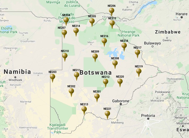
NARS-Botswana was a temporary project to determine the Earth structure beneath Botswana to obtain a better understanding of its complex tectonics. The Seismology Group of Utrecht University deployed a 21 broadband seismic station network across the Republic of Botswana in cooperation with the Department of Geological Survey of the Republic of Botswana (DGS), the Department of Earth Systems Analysis of the Technical University of Twente (ITC) and the Africa Array (AA). The project had a duration of 4 years starting in June 2013 and ending 2018. March 1st 2018, the ownership of the stations was transferred to the Botswana Geoscience Institute (BGI), making the stations part of the Botswana Seismological Network (BSN).
Station list & data
Publications
Paulssen H., Micallef, T, Bouwman,D.R., Ruigrok, E., Herman, M., Fadel, I., van der Meijde, M., Kwadiba, M., Maritinkole, J., Ntibinyane, O., 2022. Rifting of the Kalahari Craton through Botswana? New seismic evidence, Journal of Geophysical Research, 127(4), e2021JB023524. https://doi.org/10.1029/2021JB023524.
White-Gaynor A.L., Nyblade A.A., Durrheim R., Raveloson, van der Meijde M., Fadel I., Paulssen H., Kwadiba M., Ntibinyane O., Titus N., Sitalli M, 2021. Shear-wave velocity structure of the Southern African upper mantle: Implications for craton structure and plateau uplift, Geophysical Research Letters, 48(7), e2020GL091624. https://doi.org/10.1029/2020GL091624
Fadel I., Paulssen H., van der Meijde M., Kwadiba M., Ntibinyane O., Nyblade A.,Durrheim R., 2020. Crustal and upper mantle shear wave velocity structure of Botswana: The 3 April 2017 central Botswana earthquake linked to the East African Rift System, Geophysical Research Letters, 47(4). https://doi.org/10.1029/2019GL085598
White-Gaynor A.L., Nyblade A.A., Durrheim R., Raveloson, van der Meijde M., Fadel I., Paulssen H., Kwadiba M., Ntibinyane O., Titus N., Sitalli M, 2020. Lithospheric boundaries and upper mantle structure beneath southern Africa imaged by P and S wave velocity models, Geochemistry Geophysics Geosystems, 21(10). https://doi.org/10.1029/2020GC008925
Fadel I., Paulssen H., van der Meijde M., Kwadiba M., Ntibinyane O., Nyblade A.,Durrheim R., 2020. Crustal and upper mantle shear wave velocity structure of Botswana: The 3 April 2017 central Botswana earthquake linked to the East African Rift System, Geophysical Research Letters, 47(4). https://doi.org/10.1029/2019GL085598
Ortiz K., Nyblade A., van der Meijde M., Paulssen H., Kwadiba M., Ntibinyane O., Durrheim R., Fadel I., Homman K., 2019. Upper mantle P and S wave velocity structure of the Kalahari Craton and surrounding Proterozoic terranes, southern Africa, Geophysical Research Letters, 46(16), 9509-9518. https://doi.org/10.1029/2019GL084053
Micallef, T., 2019. Earthquake detection and localisation using the NARS-Botswana data. MSc thesis, Utrecht University. PDF
Bouwman, D., 2019. Relocating aftershocks of the 2017 Moiyabana, Botswana earthquake. MSc thesis, Utrecht University. PDF
Fadel, I., van der Meijde, M., Paulssen H., 2018. Crustal structure and dynamics of Botswana, Journal Geophysical Research, 123(12). https://doi.org/10.1029/2018JB016190 .
Equipment
Seismometers
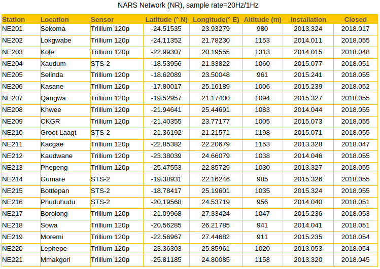
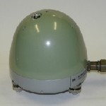 The seismometers used in the NARS Botswana project were the Nanometrics Trillium 120 (left) and the Streckeisen STS-2 (right) broad band sensors. Both are electronic force-feedback sensors that provide an output signal proportional to ground velocity over a broad frequency range. Three identical obliquely-oriente
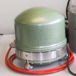 d mechanical sensors are used and standard vertical and horizontal outputs are derived by summing the raw sensor signals within the sensors electronics. The housing is vacuum-tight and designed to minimize the distortion of the package by barometric pressure changes.The sensors are designed for quick and simple installation, wide temperature range operation, and secure transport, while resolving minimum earth noise levels over the frequency range.
NARS data logger
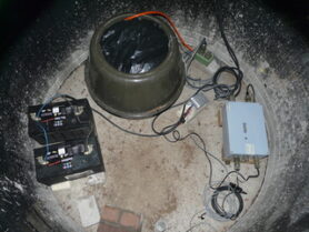
 The Seismology group of Utrecht University together with the Instrumental group of the Physics department, developed the NARS seismic data logger. The data logger consists of mainly two components: (1) a data acquisition module, which does the AD conversion and timing. (2) an off-the-shelf embedded computer, for all further data processing. Data is stored on the data logger’s internal hard disk and (optionally) to an external USB stick. All communication with the outside world is done by network communication. The data acquisition module is similar as used with our previous NARS Baja project. For more detailed hardware information go to NARS data logger
Timing
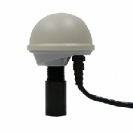 For the NARS data logger timing we use the Trimble Acutime Gold GPS smart antenna. It generates a pulse-per-second (PPS) output synchronized to UTC within 15 nanoseconds, outputting a timing and position packet for each pulse.
GSM
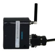 By GSM modem, the datalogger sends daily a short message (SMS) to Utrecht University with all important status information. It is also possible to make a GSM data connection and communicate directly with the datalogger system.
Portable computer
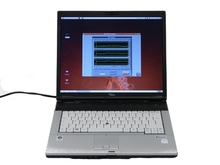 For station setup, data collection and communication with the datalogger we use a portable computer running Linux. Communication is established by Ethernet using the virtual console program Xvnc.
For more detailed software information visit the NARS Baja equipment page.
Site Preparation
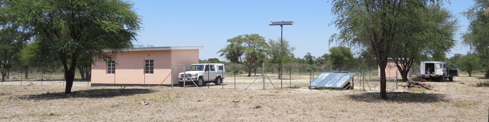
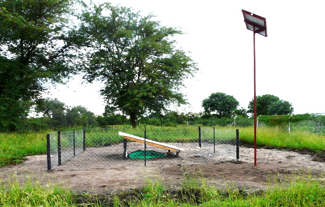
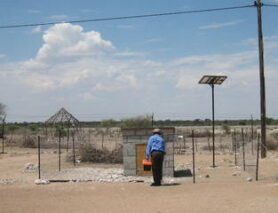
A potentially good site for a broad band seismic station is on hard-rock and far away from cultural noise. However, in remote places, such as Botswana, most places have soft and sandy soil and theft or vandalism of the equipment is a great concern. We chose to install most stations on terrains of primary schools which have 24/7 guarding and are well distributed across the country and taking the higher ambient noise for granted.
Construction
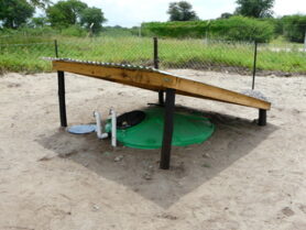
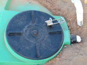
Most areas in Botswana have sandy soil and few of them have hard rock or clay. At the sandy locations we use our “Flow-Tek water tank setup” as illustrated in the figure below. We dig a steep pit that will fit to the size of a 2500 Litre water tank (Flow-Tek Botswana) and pour a 15 cm layer of concrete at the bottom of the pit. The tank, from which the middle part of the bottom was cut out, is placed in the pit and extra concrete is poured through the man hole at the top. Finally we end up with a bottom thickness of 25 cm or more. To avoid signals due to expansion problems, no iron is used. The concrete will stick to the underground and by covering the tank bottom slab, a water tight construction is created. At the top and the bottom of the tank tube holes are used for air ventilation and these are covered with gauze against animals.
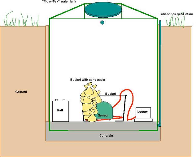
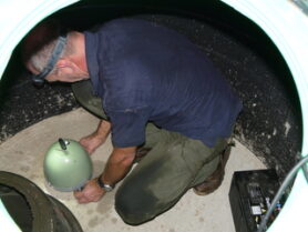
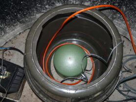
The sensor is placed in a bottomless bucket, directly on the concrete floor. After adjusting the sensor, the bucket is filled with sand bags for extra temperature insulation. These can easy be removed in case of a sensor problem.
To keep sun and rain away, a sloping roof is placed over the tank. The tank man hole lid has a screw-thread and is therefore easy to lock with a padlock.
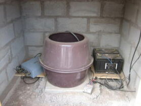
In those cases where the ground is too hard to get in, we built a small shelter from stone. Hollow bricks and a double roof are used for temperature insulation.
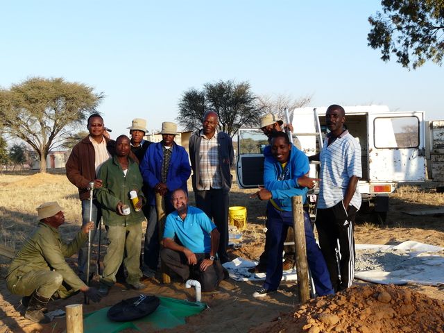
The “A team”
Without the effort of our BGI colleague in Botswana, it would not have been possible to set up this seismic network.
Positioning
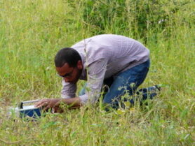
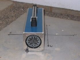
The seismometer should be oriented as close as possible along the geographical NS and EW directions. A magnetic compass measures the direction to the magnetic pole, but has to be corrected for the local declination. At station locations with metal in the construction a magnetic compass is impossible to use and therefore we use a Gyro compass in combination with a magnetic compass. First, we measure the magnetic positions at least at two different places to be sure that the presence of metal in the ground did not disturb the measurement. Then the gyro is exactly positioned along the compass and adjusted for declination. Now the gyro points exactly to the geographical NS direction.
Power
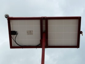
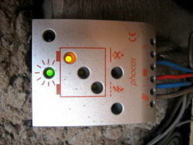
To be independent from local the local electricity net, all sites are powered by solar energy. The total power consumption of a NARS station is only 15 Watt, therefore a panel of 140 Watt is installed in combination with 2 x 10⁵ Amp Hour batteries. When fully charged, it will keep the station running for at least 5 days in case of overcast. An intelligent charge controller regulates the power and prevents the battery from overcharging. The data logger is connected directly to the batteries and not at the controller load. Only the GSM modem is connected at that terminal. Depending on the battery charge level, the data logger power monitor will shut down or reboot the data logger system. This will avoid an uncontrolled power switch off by the charge controller what could lead to a data logger disk crash. The solar panels are mounted on poles made of old drill pipes from the DGS (Department of Geological Survey, Botswana) . The panel is mounted in a slot frame and closed with a padlock. On top of the frame we mounted the GPS modem. Cables are going inside the drill pipe and in the ground to the Flow-Tek tank with instruments.